Research: Agents
ThinkGeo: Evaluating Tool-Augmented Agents for Remote Sensing Tasks
When disaster strikes, analysts need to quickly count damaged buildings, assess flood extent, and coordinate emergency response—all from satellite imagery. These tasks require sophisticated spatial reasoning, multi-step planning, and precise tool coordination that current AI benchmarks don't capture.
New research by Shabbir et al. introduces ThinkGeo, addressing a critical gap in how we evaluate AI agents for real-world remote sensing applications.
𝐖𝐡𝐲 𝐭𝐡𝐢𝐬 𝐦𝐚𝐭𝐭𝐞𝐫𝐬:
Existing AI benchmarks focus on general tasks or web scenarios, but remote sensing demands unique capabilities: reasoning over geodetic metadata, handling
spatial resolutions, temporal analysis, and unit-aware calculations. A system might need to detect flooded areas, count vehicles within those areas, and calculate precise distances—all requiring coordinated tool use and spatial precision that current evaluations miss.
𝐊𝐞𝐲 𝐢𝐧𝐧𝐨𝐯𝐚𝐭𝐢𝐨𝐧𝐬:
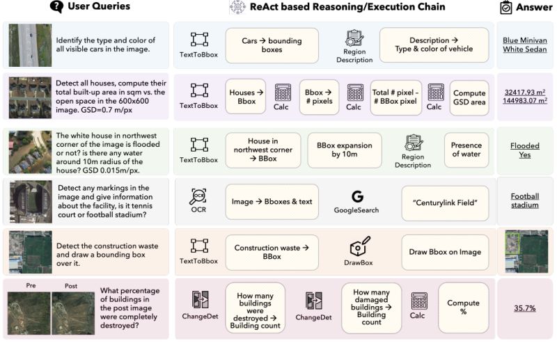
◦ 𝐑𝐞𝐚𝐥-𝐰𝐨𝐫𝐥𝐝 𝐬𝐜𝐞𝐧𝐚𝐫𝐢𝐨𝐬: 436 tasks across seven domains—urban planning, disaster assessment, environmental monitoring, transportation analysis, aviation monitoring, recreational infrastructure, and industrial sites
◦ 𝐆𝐞𝐧𝐮𝐢𝐧𝐞 𝐦𝐮𝐥𝐭𝐢-𝐬𝐭𝐞𝐩
𝐫𝐞𝐚𝐬𝐨𝐧𝐢𝐧𝐠: Tasks require agents to plan tool sequences without explicit guidance, using 14 specialized tools for perception, logic, and visualization
◦ 𝐒𝐩𝐚𝐭𝐢𝐚𝐥 𝐠𝐫𝐨𝐮𝐧𝐝𝐢𝐧𝐠: Built on 311 high-resolution satellite and aerial images, requiring precise spatial calculations and unit conversions
◦ 𝐂𝐨𝐦𝐩𝐫𝐞𝐡𝐞𝐧𝐬𝐢𝐯𝐞 𝐞𝐯𝐚𝐥𝐮𝐚𝐭𝐢𝐨𝐧: Both step-by-step execution tracking and final answer assessment, revealing where agents fail in the reasoning chain
𝐓𝐡𝐞 𝐫𝐞𝐬𝐮𝐥𝐭𝐬:
GPT-4o achieved the best overall performance but
still struggled with argument formatting and spatial precision. Open-source models showed high tool error rates—some making aggressive tool calls with poor execution control. Even top models demonstrate significant gaps in multimodal spatial reasoning, highlighting the complexity of geospatial workflows.
𝐁𝐢𝐠𝐠𝐞𝐫 𝐢𝐦𝐩𝐚𝐜𝐭:
ThinkGeo provides the first systematic way to evaluate AI agents on spatially grounded, precision-critical tasks. As remote sensing becomes increasingly important for climate monitoring, urban planning, and disaster response, we need AI systems that can handle the inherent complexity of geospatial analysis.
This benchmark establishes a foundation for building more capable spatial reasoning agents—systems that could eventually assist analysts in time-critical scenarios where accuracy literally saves lives.
|